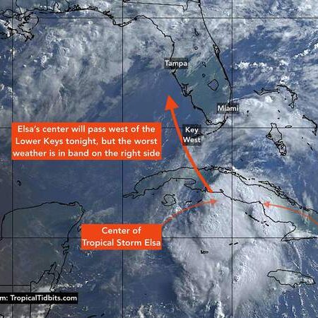
The center of Tropical Storm Elsa is just about to move over the south coast of Cuba. It will emerge into the Florida Straits tonight. The storm looks messy on the satellite, but the top wind speed has not changed much. The main feature of the storm is the band of strongest winds and heaviest rain well displaced from the center to the east – on the right side. That will come into play late tonight and early tomorrow when the storm center passes the Keys.
The winds will likely decrease some over land, and then increase a bit when the system gets over the Gulf of Mexico and moves north along the west coast of Florida. Everybody from Naples to north of Tampa Bay needs to pay close attention. It might not be a trivial storm along that vulnerable West Florida coastline.
The center of Elsa is likely to swing west of Key West. But recall that the storm is right-side loaded. That persistent feeder band is 40 or 50 miles from the center, arcing around the right side. If the National Hurricane Center’s forecast track of the center is correct, the bad weather will extend out of the cone and directly affect the Keys.
That band of squally weather with embedded winds 50 to 60 mph with higher gusts will likely impact the Lower and some of the Middle Keys as Elsa’s center of rotation moves north.
The storm parallels the west coast of Florida, that feeder bank might well sit over the same part of the Keys for a while, so very heavy rain totals can be expected in some areas. The National Weather Service is predicting up to 6 inches of rain in the areas where the bands of rain are persistent. I could imagine even more, so be aware.
It’s impossible to know exactly where the main bands with the heaviest rain and the gustiest winds will set up, so everyone in the Middle and Lower Keys needs to take precautions.
Pay attention to instructions from Monroe County officials, especially if you live on a boat or in an RV or other temporary home.
In the Upper Keys, a fairly strong band of storms can’t be ruled out, but the winds wouldn’t likely be as strong. Still, gusts over 40 mph are possible.
In Miami-Dade, Broward, and up the coast, some strong gusts are possible in some tropical squalls, but the southeast coast of Florida should only get fringe effects.
In the end, the biggest impact of Elsa in Florida might end up being on the west coast of the state. Elsa is forecast to arc out over the Gulf slightly before bending to the right and impacting the Florida peninsula somewhere around Tampa/St. Petersburg. But it may come close enough to the entire coastline to be a problem.
Because the strongest winds will be on the right side of the storm, those winds will be driving water toward the coast from Naples north to Tampa Bay at least. In the area south of Tampa, the biggest storm surge will likely come after Elsa’s center passes.
When Elsa makes landfall somewhere near the Tampa Bay area late Tuesday or early Wednesday, the maximum storm surge will be pushed ashore, which will likely flood low-lying areas. Residents near the water all along the Florida west coast should stay well informed.
Nothing is showing up in the long-range computer models after Elsa. So hopefully Mother Nature will settle down and we can get back on something like a regular schedule. Even by busy modern standards, Elsa is very early. On average, the 5th named storm of the year doesn’t come along until August 10th.
:strip_exif(true):strip_icc(true):no_upscale(true):quality(65)/cloudfront-us-east-1.images.arcpublishing.com/gmg/3RWE5RNKLJGD7PJXNXM7AJP5IM.jpg)
